By R.B. Moreno
The last several days of travel along the Pan-American Highway have taken my sister and I through a number of locales: a city renowned for producing Peru's best wine, a marine reserve prized for its natural fertilizer, a desert rich with archaeology. We're now exploring Lima, where the menu choices multiply so fast that confusion sometimes prevails.

Ica produces wine as well as pisco, a brandy made from grapes. Local vineyards trade their wares as far as Lima, while industrial giant Vista Alegre, Peru's largest bodega, serves international markets.

Beyond vineyards, the thing in Ica that most surprised this writer was a demonstration on behalf of AIDS awareness by local students -- featuring dancing condoms.

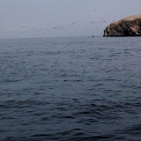
Between Ica and Lima lies the Paracas National Reservation, a marine sanctuary comprising some nine square miles of peninsula. Just offshore lies a group of islands so prized for guano, the dried dung of seabirds, that Chinese laborers were enslaved and shipped across the Pacific by the thousands during the 1800s to harvest the fertilizer. Stocks of guano and the numbers of cormorants and bobbies that produce it have sharply declined in past decades, due in part to overfishing. With commodity prices rising, the
New York Times points out that demand for guano is spiking. Our guide in Paracas, Jesus Guardo, said the Ballesta Islands, pictured below, come due for harvest every couple of years.
A visit to Lima this week would not have been complete without taking in a new film:
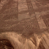
Indiana Jones and the Kingdom of the Crystal Skull, playing at the local 12-screen cineplex. Evidently the screenwriters thought the geoglyphs and mummies of Nasca, Peru would provide a nice plot point, as much of the film's action rides roughshod over a desert landscape we toured a few days ago. Be warned, archaeology majors: pre-Columbian native history gets such poor treatment in this film that you must cast aside everything you hold dear in order to sit quietly for 124 minutes. For a view of what the Nasca lines and nearby Chauchilla mummies really look like, try the slideshow above.
Postscript (March 1, 2010) -- This month's issue of
National Geographic highlights new research helping to explain the origin of Peru's geoglyphs. Some excerpts:
These new findings make an important point about the Nasca lines: They were not made at one time, in one place, for one purpose. Many have been superimposed on older ones, with erasures and overwritings complicating their interpretation; archaeologist Helaine Silverman once likened them to the scribbling on a blackboard at the end of a busy day at school. The popular notion that they can be seen only from the air is a modern myth. The early Paracas-era geoglyphs were placed on hillsides where they could be seen from the pampa. By early Nasca times the images -- less anthropomorphic, more naturalistic -- had migrated from the nearby slopes to the floor of the pampa. Almost all of these iconic animal figures, such as the spider and the hummingbird, were single-line drawings; a person could step into them at one point and exit at another without ever crossing a line, suggesting to archaeologists that at some point in early Nasca times the lines evolved from mere images to pathways for ceremonial processions. Later, possibly in response to explosive population growth documented by the German-Peruvian team, more people may have participated in these rituals, and the geoglyphs took on open, geometrical patterns, with some trapezoids stretching more than 2,000 feet. "Our idea," [German archaeologist Markus] Reindel says, "is that they weren't meant as images to be seen anymore, but stages to be walked upon, to be used for religious ceremonies." ... In 1986 [Johan] Reinhard reported finding ruins of a ceremonial stone circle at the summit of Illakata, at over 14,000 feet one of the tallest mountains feeding runoff to the Nasca drainage system. Along with other traces of ritual activity at the top of Nasca watersheds, the discovery led him to propose that one of the main purposes of the Nasca lines was related to the worship of mountain deities ... because of their connection to water.